lidar laser range sensor
- time:2025-09-13 04:24:27
- Click:0
Lidar Laser Range Sensors: Mapping the World with Pinpoint Light Precision
Imagine a self-driving car navigating a complex urban intersection at night, a robot vacuum seamlessly avoiding chair legs and pet toys, or an aerial drone meticulously mapping the contours of an ancient forest canopy. At the heart of these feats of modern technology often lies a critical component: the Lidar Laser Range Sensor. More than just measuring distance, these sophisticated devices unlock the power to perceive and map the 3D world with unprecedented accuracy and speed, becoming indispensable eyes for machines.
Understanding the Core: Light Detection and Ranging
Lidar, an acronym for Light Detection and Ranging, is fundamentally a sophisticated laser-based remote sensing method. While the term “sensor” aptly describes its function, Lidar systems encompass both the core laser ranging unit and sophisticated data processing to interpret the returning signals. The core principle resembles radar or sonar but utilizes focused beams of light instead of radio waves or sound.
The essential operation of a laser range sensor within a Lidar system is elegantly precise:
- Laser Pulse Emission: The sensor emits a short, intense pulse of laser light (typically infrared for eye safety and atmospheric penetration, though visible and near-IR are also used).
- Target Interaction: This laser pulse travels through the air and strikes an object in its path.
- Reflected Signal Capture: A portion of the light reflects off the object’s surface.
- Time-of-Flight Calculation: An extremely sensitive photodetector within the sensor captures the returning signal. Crucially, the system precisely measures the time-of-flight (ToF) – the exact duration it takes for the laser pulse to travel to the target and back.
- Distance Determination: Since the speed of light (
c) is a known constant (~300,000 km/s), the distance (d) to the object is calculated simply using the formula: d = (c * t) / 2, where t is the measured time-of-flight. Dividing by 2 accounts for the round trip.
Beyond the Single Point: Creating a 3D World View
A standalone laser range sensor provides a single distance measurement along its emission axis. True Lidar systems elevate this capability significantly:
- Scanning Mechanisms: Lidar units incorporate mechanisms (rotating mirrors, MEMS mirrors, phased arrays) to rapidly sweep the laser beam across a wide field of view – horizontally (azimuth) and often vertically (elevation).
- Point Cloud Generation: Each laser pulse fired during the scan, when its distance is calculated, generates a single data point in 3D space. The precise angle of the beam at the moment of emission defines the
x,y position relative to the sensor, while the distance calculation defines the z (depth) coordinate. Millions of these points, gathered per second, form a massive dataset known as a point cloud.
- Environment Modeling: Sophisticated software processes this point cloud data to create highly detailed, accurate 3D models or maps of the scanned environment. This real-time 3D mapping capability is what makes Lidar transformative.
Why Choose Lidar? Key Advantages Over Alternatives
Lidar laser range sensors offer unique benefits that often make them superior to other sensing modalities like cameras or radar in specific applications:
- Exceptional Accuracy and Resolution: Modern Lidar sensors achieve centimeter-level range accuracy at significant distances (tens to hundreds of meters). The dense point clouds provide millimeter-level spatial resolution, capturing fine details of objects and surfaces. This high-resolution distance measurement is critical for applications like autonomous navigation and precision mapping.
- Direct 3D Measurement: Unlike cameras which require complex algorithms (stereo vision, structure from motion) to infer depth, Lidar directly measures distance to each point. This yields inherently metric 3D data without reliance on texture or lighting conditions. This capability for precise spatial awareness is fundamental.
- Performance in Challenging Lighting: Lidar largely operates independently of ambient light. It functions effectively in complete darkness and maintains accuracy under bright, direct sunlight or situations with poor contrast where cameras struggle. This robustness in variable illumination is a major operational advantage.
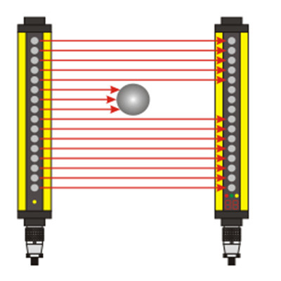
- Object Detection and Avoidance: The direct distance measurement and high resolution enable Lidar to detect small objects at range, critical for safety-critical applications like autonomous vehicles evading debris or robots navigating dynamic environments. It provides the precise spatial data needed for effective collision avoidance systems.
- Velocity Measurement (Doppler Lidar): Advanced Frequency-Modulated Continuous-Wave (FMCW) Lidar systems can measure the velocity of moving objects using the Doppler shift of the reflected signal, adding another layer of valuable data.
Ubiquitous Applications: Where Lidar Shines
The unique capabilities of Lidar laser range sensors drive their adoption across diverse fields:
- Autonomous Vehicles (AVs): The cornerstone sensor for most AVs, providing real-time, high-resolution 3D mapping of the vehicle’s surroundings for localization, path planning, and object detection/avoidance. It’s crucial for interpreting complex driving environments.
- Robotics and Automation: From warehouse robots to agricultural machinery and consumer vacuums, Lidar enables autonomous navigation, obstacle avoidance, simultaneous localization and mapping (SLAM), and precise manipulation tasks in unstructured environments.
- Topographic Surveying & GIS: Revolutionizing land surveying, forestry, and geology by rapidly creating highly accurate digital elevation models (DEMs) and terrain maps, even through dense vegetation canopy.
- Infrastructure & Construction: Enabling precise as-built documentation, monitoring structural deformations, planning construction sites, and conducting volumetric surveys (e.g., stockpile measurement).
- Environmental Monitoring: Used for measuring vegetation density and height, coastal erosion studies, glacier monitoring, and atmospheric aerosol profiling.
- Archaeology & Cultural Heritage: Creating detailed 3D models of historical sites, ruins, and artifacts for documentation, preservation, and virtual exploration.
- Security & Defense: Employed in surveillance, perimeter monitoring, target acquisition, and guidance systems due to its accuracy and all-weather/day-night capabilities.
The Evolving Landscape and Future
Lidar technology is rapidly advancing. Key trends include:
- Solid-State Lidar (SSL): Moving away from large, rotating mechanical assemblies towards chip-based designs using MEMS mirrors or optical phased arrays. This promises smaller size, lower cost, higher reliability, and faster scanning speeds – critical for mass-market adoption in consumer products and automotive.
- Cost Reduction: Significant manufacturing innovations and economies of scale are driving down the cost of Lidar sensors, making them accessible to wider markets.
- Increased Performance: Ongoing research pushes the boundaries in terms of range, resolution, frame rate, and field of view.
- Sensor Fusion: Combining Lidar data with cameras, radar, and inertial sensors provides a more robust, comprehensive perception system, leveraging the strengths of each modality.
The Lidar laser range sensor is far more than a simple distance meter. It is an enabling technology for perceiving the world in precise, measurable 3D. As it continues to shrink in size and cost while leaping forward in performance, its integration into our machines, vehicles, and daily tools will only deepen, fundamentally shaping how we interact with and understand the physical world around us. From enabling the autonomous future to preserving our past and managing our environment, precise light-based ranging is illuminating the path forward.